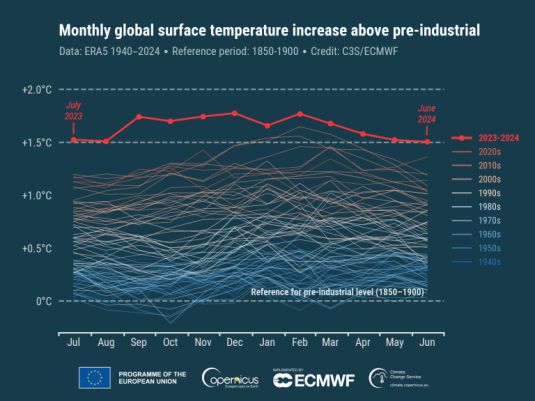
The average global temperature has been 1.5°C above the pre-industrial era for 12 successive months, according to new data issued by the European Union’s Copernicus Climate Change Service.

It was the hottest June on record for the globe and the 13th month in a row to set a monthly temperature record. While unusual, a similar streak of monthly global temperature records happened previously in 2015/2016.
According to Copernicus Climate Change Service ERA5 data, the month was 1.50°C above the estimated June average for 1850-1900, the designated pre-industrial reference period. This is the 12th consecutive month to reach or break the 1.5°C threshold.
The global-average temperature for the past 12 month period (July 2023 – June 2024) is 1.64°C above the 1850-1900 pre-industrial average, according to the ERA5 dataset.
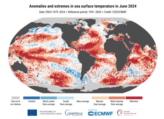
The sea surface temperature (SST) averaged for June 2024 over 60°S–60°N was 20.85°C, the highest value on record for the month. This is the fifteenth month in a row that the SST has been the warmest in the ERA5 data record for the respective month of the year.
“These latest figures from the Copernicus Climate Change Service unfortunately highlight that we will be exceeding the 1.5°C level on a temporary basis with increasing frequency, on a monthly basis. However, it is important to stress that temporary breaches do not mean that the 1.5 °C goal is permanently lost because this refers to long-term warming over at least two decades,” said WMO Secretary-General Celeste Saulo.
Under the Paris Agreement, countries agreed to keep long-term global average surface temperature well below 2°C above pre-industrial levels and pursue efforts to limit it to 1.5°C by the end of this century. The scientific community has repeatedly warned that warming of more than 1.5°C risks unleashing far more severe climate change impacts and extreme weather and every fraction of a degree of warming matters.
Even at current levels of global warming, there are already devastating climate impacts. These include more extreme heatwaves, extreme rainfall events and droughts; reductions in ice sheets, sea ice, and glaciers; accelerating sea level rise and ocean heating.
“June witnessed widespread and prolonged heatwaves in many countries, with major impacts on all aspects of people’s life. This was even before the traditional peak of the northern hemisophere summer, which will undoubtedly see more extreme heat. The record sea surface temperatures are of great concern to vital marine ecosystems and they also provide energy to super-charge tropical cyclones – as we saw with Hurricane Beryl,” said Celeste Saulo.
WMO uses six international datasets, including ERA5, for its state of the climate monitoring. It is important to note that other datasets may not confirm the 12-month streak highlighted by Copernicus Climate Change Service, due to the relatively small margins above 1.5°C of ERA5 global temperatures for July and August 2023, May and June 2024, and differences among the various datasets.
Copernicus Climate Change Service is implemented by the European Centre for Medium-Range Weather Forecasts on behalf of the European Commission with funding from the EU. It routinely publishes monthly climate bulletins.
"Even if this specific streak of extremes ends at some point, we are bound to see new records being broken as the climate continues to warm. This is inevitable, unless we stop adding greenhouse gases into the atmosphere and the oceans," said Carlo Buontempo, Director of the Copernicus Climate Change Service.

European temperatures were most above average over southeast regions and Türkiye, but near or below average over western Europe, Iceland and northwestern Russia.
Outside Europe, temperatures were most above average over eastern Canada, the western United States and Mexico, Brazil, northern Siberia, the Middle East, northern Africa and western Antarctica.
Temperatures were below average over the eastern equatorial Pacific, indicating a developing La Niña, but air temperatures over the ocean remained at an unusually high level over many regions.
June 2024 was wetter than average over Iceland, central and most of south-western Europe, with heavy precipitation leading to floods in regions of Germany, Italy, France and Switzerland.
The month was drier than average over Ireland, most of the UK, southern Italy and much of Eastern Europe, particularly around the Black Sea.
Outside Europe, in June 2024, it was wetter than average over parts of North America, with a series of storms, including exceptional Hurricane Beryl. It was wetter than average also over south-western and south-eastern Asia, southernmost Africa, regions of Australia and South America.
Drier-than-average conditions were seen across North America, several regions of Asia and most of South America. Severe wildfires occurred in northeastern Russia and central South America.
Arctic sea ice extent was 3% below average, close to the values observed most years since 2010.
Antarctic sea ice extent was 12% below average, the second-lowest extent for June in the satellite data record, behind the lowest June value of -16% observed in 2023.

 Tel:+86-400 961 6990 Email:info@healthyphoton.com
Add:Room 305, Building 1, Zhongchuang Science Park, Jinyuan Road, Panhuo Street, Yinzhou District, Ningbo City,China


